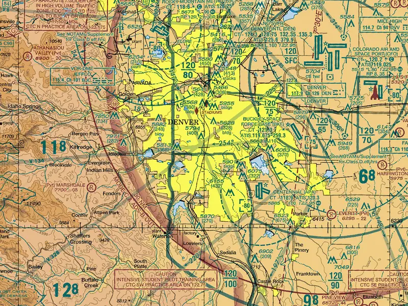
Sectional chart: the FAA VFR chart at your location, legend explained
Type a ZIP code or a city, or tap the chart: the FAA's current sectional chart opens at your spot. Then tap any symbol to see what it means for a drone flight, in plain words.
Sectional chart at your location
The FAA's VFR sectional chart, current edition, at a ZIP code, a city, your location or a spot you tap. The chips beside it open the legend: what each mark means for a drone.
Drag or use the arrow keys to move the chart. Plus and minus zoom. A tap, Enter or Space marks a spot.
FAA VFR sectional chart, edition effective Oct 29, 2026. Next edition: Dec 24, 2026. Not for navigation. A web view of the FAA chart, resampled for the screen; plan flights on the current FAA chart.
A planning view of the FAA's chart, kept on this site and shown at screen resolution. A sectional is printed every 56 days, so it cannot show today's TFRs, NOTAMs or the heights LAANC can approve: check the spot itself before you fly.
How the sectional chart viewer works
Type a place or tap the chart: the viewer shows the FAA's current VFR sectional around it and names the sectional your spot is on. The chart is the FAA's own; your spot stays on the page.
Find your spot on the chart
Type a five-digit ZIP code, a city and state, or coordinates; tap Use my location; or tap anywhere on the chart. The chart moves to the spot, drops a pin and names the sectional it is on, or both sectionals near a chart's edge. Drag to move the chart. Pinch, double-tap or use the + and − buttons to zoom (on a computer, the mouse wheel with the Ctrl key). With a keyboard, the arrow keys move it, + and − zoom, and Enter marks the middle.
Then read the marks around the pin. The chips next to the chart open the legend at the symbol you need: Class B, C, D and E airspace, floors and ceilings, restricted areas and MOAs, TFRs, airports, obstacles and the edition date.
Where the chart comes from
The FAA's Aeronautical Information Services publishes its VFR sectional charts as a web map made of small square tiles. This site keeps a copy of each tile a visitor asks for and serves it from here, so your browser talks to this site only. When the FAA posts a new 56-day edition, the viewer moves to it, and the line under the chart says which edition you see and when the next one takes effect.
The viewer covers every sectional: the 48 contiguous states, Alaska and Hawaii, with the Mariana and Samoan insets from the back of the Hawaiian chart. Puerto Rico has no sectional (the FAA charts it on its Caribbean VFR charts), so the viewer has no chart to show there.
What it does not show
A sectional is printed every 56 days. It cannot show TFRs issued since, NOTAMs, or the heights LAANC can approve near an airport. The view is resampled for the screen, so small type can blur when you zoom in. It is a planning view and not for navigation. No account, no cookies; your location is used in your browser only, and nothing about you is stored.
Check the whole spot
The chart shows the airspace. Can I fly here? answers for one spot and hour: airspace and LAANC heights, TFRs, parks, the 400 ft ceiling, wind and daylight.
Can I fly here?TFRs are not on the chart
Only a few standing restrictions are printed. Wildfire, VIP, stadium-event and launch TFRs come by NOTAM. The TFR map shows every one in force now.
TFR mapSectional chart legend, symbol by symbol
Tap a symbol to see how the chart draws it and what it means for a drone flight. The exact rule is folded under each one.
40 symbols that matter for a drone flight, drawn by Windhorse after the FAA Aeronautical Chart Users' Guide (effective July 9, 2026) and checked against it on Nov 15, 2026. The guide and the legend panel printed on every chart hold the rest. The colors are the chart's, so they stay light in dark mode.
Airspace: lines, shading and numbers
Blue and magenta lines mark controlled airspace; the numbers give its floor and ceiling.
Class B airspaceAuthorization
On the chart: Solid blue lines. Each part carries two blue numbers, its ceiling over its floor, in hundreds of feet above sea level (MSL): 100 over SFC means from the surface up to 10,000 ft.
For your drone: The airspace around the busiest airports, built in layers like an upside-down wedding cake. Under a part whose floor is SFC, a drone needs FAA airspace authorization (LAANC or FAA DroneZone) before it takes off. Under a higher shelf, such as 100 over 30, the floor is 3,000 ft MSL, and the airspace at drone height is whatever lies below it.
The exact rule
No person may operate a small unmanned aircraft in Class B, Class C, or Class D airspace or within the lateral boundaries of the surface area of Class E airspace designated for an airport unless that person has prior authorization from Air Traffic Control (ATC).14 CFR 107.41; 49 U.S.C. 44809(a)(5)
On the chart: FAA Aeronautical Chart Users' Guide (July 9, 2026), p. 16 and 26; 14 CFR 107.41 (eCFR, Nov 9, 2026); 49 U.S.C. 44809(a)(5).
Class C airspaceAuthorization
On the chart: Solid magenta lines and magenta numbers, ceiling over floor in hundreds of feet MSL. A ceiling of T means up to, but not including, the floor of the Class B above.
For your drone: The airspace around a mid-size airport with a tower and radar: usually an inner circle from the surface and an outer shelf. Inside the inner circle (SFC), a drone needs authorization. Under the outer shelf the floor is written in MSL: subtract the ground elevation and it is well above 400 ft, so check what airspace lies under it.
Drone airspace classes, side by side
The exact rule
No person may operate a small unmanned aircraft in Class B, Class C, or Class D airspace or within the lateral boundaries of the surface area of Class E airspace designated for an airport unless that person has prior authorization from Air Traffic Control (ATC).14 CFR 107.41; 49 U.S.C. 44809(a)(5)
On the chart: FAA Aeronautical Chart Users' Guide (July 9, 2026), p. 16 and 26; 14 CFR 107.41 (eCFR, Nov 9, 2026); 49 U.S.C. 44809(a)(5).
Class D airspaceAuthorization
On the chart: A blue dashed line around an airport with a tower. The ceiling sits in a dashed blue box, in hundreds of feet MSL: 25 means up to 2,500 ft; -25 means up to but not including 2,500 ft.
For your drone: The airspace of a smaller towered airport, from the ground up to the boxed ceiling. A drone needs authorization anywhere inside the dashed line. A note such as "See NOTAMs/Supplement for Class D eff hrs" means it is part-time: the Chart Supplement gives its hours and what the airspace becomes after them.
The exact rule
No person may operate a small unmanned aircraft in Class B, Class C, or Class D airspace or within the lateral boundaries of the surface area of Class E airspace designated for an airport unless that person has prior authorization from Air Traffic Control (ATC).14 CFR 107.41; 49 U.S.C. 44809(a)(5)
On the chart: FAA Aeronautical Chart Users' Guide (July 9, 2026), p. 16 and 27; 14 CFR 107.41 (eCFR, Nov 9, 2026); 49 U.S.C. 44809(a)(5).
Class E surface areaAuthorization
On the chart: A magenta dashed line, around an airport without a tower or as an extension of a towered airport's airspace.
For your drone: Controlled airspace that starts at the ground. For drones it counts with Class B, C and D: a drone needs authorization inside the magenta dashed line, for Part 107 and recreational flights alike.
Drone airspace classes, side by side
The exact rule
No person may operate a small unmanned aircraft in Class B, Class C, or Class D airspace or within the lateral boundaries of the surface area of Class E airspace designated for an airport unless that person has prior authorization from Air Traffic Control (ATC).14 CFR 107.41; 49 U.S.C. 44809(a)(5)
On the chart: FAA Aeronautical Chart Users' Guide (July 9, 2026), p. 17 and 27; 14 CFR 107.41 (eCFR, Nov 9, 2026); 49 U.S.C. 44809(a)(5).
Class E from 700 ft above the groundNo authorization
On the chart: A soft magenta band with one sharp edge. On the side where it fades, controlled Class E airspace starts 700 ft above the ground.
For your drone: Below 700 ft that side is Class G, so a drone may fly up to 400 ft there without authorization. Outside the band, Class E usually starts at 1,200 ft above the ground.
The exact rule
The altitude of the small unmanned aircraft cannot be higher than 400 feet above ground level, unless the small unmanned aircraft: (1) Is flown within a 400-foot radius of a structure; and (2) Does not fly higher than 400 feet above the structure's immediate uppermost limit.14 CFR 107.51(b); 49 U.S.C. 44809(a)(6)
On the chart: FAA Aeronautical Chart Users' Guide (July 9, 2026), p. 17 and 27; 14 CFR 107.51(b) (eCFR, Nov 9, 2026); 49 U.S.C. 44809(a)(6).
Class E with another floorNo authorization
On the chart: A soft blue band: the edge of Class E airspace whose floor is not 700 ft, often 1,200 ft above the ground. A floor that differs again is written as a number. With no band at all, Class E starts at 1,200 ft above the ground.
For your drone: Either way the floor is far above a drone: up to 400 ft above the ground you are in Class G, with no authorization needed.
The exact rule
The altitude of the small unmanned aircraft cannot be higher than 400 feet above ground level, unless the small unmanned aircraft: (1) Is flown within a 400-foot radius of a structure; and (2) Does not fly higher than 400 feet above the structure's immediate uppermost limit.14 CFR 107.51(b); 49 U.S.C. 44809(a)(6)
On the chart: FAA Aeronautical Chart Users' Guide (July 9, 2026), p. 17 and 27; 14 CFR 107.51(b) (eCFR, Nov 9, 2026); 49 U.S.C. 44809(a)(6).
Class G (uncontrolled) airspaceNo authorization
On the chart: No line and no shading of its own: it is the airspace near the ground wherever no other class is drawn.
For your drone: Where most drone flights happen. Class G reaches up to where Class E starts: 700 or 1,200 ft above the ground, or higher where marked. A drone may fly in it up to 400 ft above the ground with no authorization, unless a restriction on top of it says otherwise.
The exact rule
The altitude of the small unmanned aircraft cannot be higher than 400 feet above ground level, unless the small unmanned aircraft: (1) Is flown within a 400-foot radius of a structure; and (2) Does not fly higher than 400 feet above the structure's immediate uppermost limit.14 CFR 107.51(b); 49 U.S.C. 44809(a)(6)
On the chart: FAA Aeronautical Chart Users' Guide (July 9, 2026), p. 17; 14 CFR 107.51(b) (eCFR, Nov 9, 2026); 49 U.S.C. 44809(a)(6).
Floor and ceiling numbers (70 over SFC)How to read
On the chart: Two numbers stacked over a bar: the ceiling on top, the floor below, in hundreds of feet above sea level (MSL). SFC is the surface; T is up to the Class B above; a + before a floor means from just above that height; a - before a boxed Class D ceiling means up to but not including it.
For your drone: Your drone's 400 ft limit is measured from the ground, the chart's numbers from the sea. Subtract the ground elevation (the nearest airport's, or a contour's): with ground at 1,000 ft, a floor of 30 starts 2,000 ft above you, and 70 over SFC starts at your feet.
The source
Rule: 14 CFR 107.51(b).
On the chart: FAA Aeronautical Chart Users' Guide (July 9, 2026), p. 16 and 27; 14 CFR 107.51(b) (eCFR, Nov 9, 2026).
Mode C veil (30 NM ring)Not a drone limit
On the chart: A thin magenta circle 30 nautical miles around a Class B airport, labelled MODE C & ADS-B OUT 30 NM.
For your drone: It sets transponder and ADS-B rules for crewed aircraft, from the surface to 10,000 ft MSL. It is not a drone limit: under Part 107 a drone may not fly with a transponder on or with ADS-B Out transmitting, unless the FAA allows it.
The exact rule
Unless otherwise authorized by the Administrator, no person may operate a small unmanned aircraft system under this part with a transponder on.14 CFR 107.52, 107.53
On the chart: FAA Aeronautical Chart Users' Guide (July 9, 2026), p. 17 and 30; 14 CFR 107.52 and 107.53 (eCFR, Nov 9, 2026).
Special use airspace and security areas
Hatched lines mark areas with their own limits; the chart margin lists their altitudes and hours.
Prohibited area (P)No-fly
On the chart: A blue line with short hatch marks on its inner side, labelled P and a number, such as P-56 in Washington, DC.
For your drone: Flight is prohibited. A drone may not fly inside without permission from the agency that uses or controls the area; treat it as a no-fly zone.
The exact rule
No person may operate a small unmanned aircraft in prohibited or restricted areas unless that person has permission from the using or controlling agency, as appropriate.14 CFR 107.45; 49 U.S.C. 44809(a)(6)
On the chart: FAA Aeronautical Chart Users' Guide (July 9, 2026), p. 17, 20 and 30; 14 CFR 107.45 (eCFR, Nov 9, 2026); 49 U.S.C. 44809(a)(6).
Restricted area (R)Permission needed
On the chart: The same blue hatched line, labelled R and a number. The table in the chart margin gives its altitudes, its hours and the agency that controls it.
For your drone: An area with hazards to aircraft that often cannot be seen from the air. A drone needs permission from the using or controlling agency to fly inside; the margin table names it and its hours.
The exact rule
No person may operate a small unmanned aircraft in prohibited or restricted areas unless that person has permission from the using or controlling agency, as appropriate.14 CFR 107.45; 49 U.S.C. 44809(a)(6)
On the chart: FAA Aeronautical Chart Users' Guide (July 9, 2026), p. 17, 20 and 30; 14 CFR 107.45 (eCFR, Nov 9, 2026); 49 U.S.C. 44809(a)(6).
Warning area (W)Check hours
On the chart: The same blue hatched line, labelled W and a number, drawn offshore.
For your drone: Hazardous activity over the water, listed with its hours in the chart margin. No drone rule names warning areas, but a drone flown from a boat or a beach near one meets the same hazards: check the hours first.
The source
Rule: 49 U.S.C. 44809(a)(6) (special use airspace designations).
On the chart: FAA Aeronautical Chart Users' Guide (July 9, 2026), p. 17, 20 and 30; 49 U.S.C. 44809(a)(6).
Alert area (A)Look out
On the chart: A magenta line with hatch marks on its inner side, labelled A and a number.
For your drone: An area with a lot of pilot training or unusual flying. A drone needs no permission, but expect crewed aircraft low and often: keep a sharp lookout and give way.
The source
Rule: None for drones beyond the general rules.
On the chart: FAA Aeronautical Chart Users' Guide (July 9, 2026), p. 17, 20 and 30.
Military Operations Area (MOA)Check if active
On the chart: A magenta hatched line around an area named in capitals with MOA, such as VANCE 2 MOA. The chart margin lists its altitudes and hours.
For your drone: Airspace set apart for training flights that can be fast and low. A drone needs no permission, but before flying inside, check whether the area is active (the margin's hours, or a NOTAM) and keep a lookout.
The source
Rule: None for drones beyond the general rules.
On the chart: FAA Aeronautical Chart Users' Guide (July 9, 2026), p. 17, 20 and 30.
Military Training Route (IR, VR)Look out
On the chart: A thin line with IR or VR and a number printed in black on it, and small arrows for the direction of flight. Four digits (VR1234): no part of the route is above 1,500 ft above the ground. Three digits or fewer (IR123): one or more parts are above 1,500 ft.
For your drone: A route for training flights at high speed and low height. A drone needs no permission, but aircraft on a four-digit route can pass very low with little warning: stay low, watch and listen.
The source
Rule: None for drones beyond the general rules.
On the chart: FAA Aeronautical Chart Users' Guide (July 9, 2026), p. 18 and 31.
National Security Area (NSA)Avoid
On the chart: A broken magenta line, often with a note asking pilots to avoid flight below a given height.
For your drone: Airspace over sites that need extra security. Pilots are asked to avoid flying through; when necessary, flight there is temporarily prohibited by NOTAM, and that prohibition binds a drone too.
The exact rule
A person acting as a remote pilot in command must comply with the provisions of §§ 91.137 through 91.145 and 99.7 of this chapter.14 CFR 99.7, 107.47
On the chart: FAA Aeronautical Chart Users' Guide (July 9, 2026), p. 18 and 30; 14 CFR 107.47 (eCFR, Nov 9, 2026).
Special Flight Rules Area (SFRA), Washington DCNo-fly core
On the chart: A blue line with small blocks along it. Around Washington, DC, the SFRA reaches 30 miles from Reagan National Airport; the Flight Restricted Zone (FRZ) inside it is drawn with the prohibited-area hatching.
For your drone: Flying a drone within 15 miles of Reagan National Airport is prohibited without specific FAA authorization. From 15 to 30 miles, recreational flights are allowed under the FAA's conditions for the area: registered, below 400 ft, in sight.
The exact rule
Flying an unmanned aircraft within the 15-mile radius inner ring is prohibited without specific FAA authorization.FAA, Washington DC No Drone Zone; 14 CFR 99.7
On the chart: FAA Aeronautical Chart Users' Guide (July 9, 2026), p. 18, 29 and 30; FAA, Washington DC No Drone Zone (last updated Sep 16, 2026).
National park, wildlife refuge or wilderness (Special Conservation Area)Parks: no drones
On the chart: A blue dotted line around the area, with its name in blue.
For your drone: The chart asks crewed aircraft to keep high above these areas. For drones the stricter rules are on the ground: the National Park Service prohibits launching, landing or operating drones in national parks, and other land agencies set their own rules.
The source
Rule: 36 CFR 1.5 (National Park Service closure).
On the chart: FAA Aeronautical Chart Users' Guide (July 9, 2026), p. 29; National Park Service, Uncrewed Aircraft in the National Parks.
NOAA-regulated National Marine Sanctuary areaCheck the note
On the chart: A purple dotted outline over the water, with a boxed note.
For your drone: The chart's note says flight below 1,000 ft above the surface in the marked zones breaks NOAA rules (15 CFR part 922). Drones fly far below that, so read the sanctuary's own rules before you fly over it.
The source
Rule: 15 CFR part 922 (as named on the chart).
On the chart: FAA Aeronautical Chart Users' Guide (July 9, 2026), p. 29.
TFRs and standing flight restrictions on the chart
Only a few long-standing restrictions are printed. Every other TFR is published by NOTAM alone.
TFR relating to national securityNo-fly
On the chart: A broken blue line. Only TFRs relating to national security are charted, and only standing ones.
For your drone: No drone flight inside without the permission the TFR names. The chart shows nothing else: wildfire, VIP, space launch, airshow and most other TFRs are never printed on a sectional, so check current TFRs before every flight.
The exact rule
A person acting as a remote pilot in command must comply with the provisions of §§ 91.137 through 91.145 and 99.7 of this chapter.14 CFR 99.7, 107.47; 49 U.S.C. 44809(a)(6)
On the chart: FAA Aeronautical Chart Users' Guide (July 9, 2026), p. 18 and 29; 14 CFR 107.47 (eCFR, Nov 9, 2026); 49 U.S.C. 44809(a)(6).
Sporting event TFR site (STADIUM)Event days
On the chart: A small magenta diamond with the word STADIUM.
For your drone: A venue where the standing sports TFR applies: no drones within 3 nautical miles, up to 3,000 ft above the ground, from one hour before to one hour after a qualifying game or race. On other days, the normal rules apply.
The exact rule
Specifically, UAS operations are prohibited within a radius of three nautical miles of the stadium or venue.FDC NOTAM 0/0367; 14 CFR 99.7, 107.47
On the chart: FAA Aeronautical Chart Users' Guide (July 9, 2026), p. 31; FAA, Stadiums and Sporting Events (last updated Nov 19, 2025); FDC NOTAM 0/0367.
National Defense Airspace TFR areaCheck NOTAMs
On the chart: An area bounded with magenta cross-hatching, with a boxed note such as "Dallas National Defense Airspace TFR, Check NOTAMs".
For your drone: Airspace under routine security TFRs that run for 12 months or more. Read the current NOTAMs before you fly anywhere inside it.
The source
Rule: 14 CFR 99.7, 107.47.
On the chart: FAA Aeronautical Chart Users' Guide (July 9, 2026), p. 18 and 31; 14 CFR 107.47 (eCFR, Nov 9, 2026).
Special Security Notice: permanent continuous flight restrictionPermission needed
On the chart: A blue circle with a boxed note, such as "Disneyland Theme Park, See Note for requirements".
For your drone: A flight restriction that does not lapse. The chart note says where its terms are; read them and the NOTAM before flying anywhere near, and expect a drone to need FAA permission inside.
The source
Rule: 14 CFR 99.7, 107.47.
On the chart: FAA Aeronautical Chart Users' Guide (July 9, 2026), p. 31; 14 CFR 107.47 (eCFR, Nov 9, 2026).
Space Operations Area (14 CFR 91.143)Launch days
On the chart: A shaded blue fan near a launch or re-entry site; the darker tint is the 91.143 area.
For your drone: Airspace that is closed by NOTAM during a launch or re-entry. On launch days, check TFRs before you fly anywhere near it.
The source
Rule: 14 CFR 91.143, 107.47.
On the chart: FAA Aeronautical Chart Users' Guide (July 9, 2026), p. 31; 14 CFR 107.47 (eCFR, Nov 9, 2026).
Activity areas
Places where other aircraft fly low or slow: no permission needed, but a sharp lookout is.
Parachute jumping areaLook out
On the chart: A magenta parachute with a radio frequency.
For your drone: Skydivers jump here, falling from thousands of feet and landing nearby. A small drone is hard for them to see and avoid: fly somewhere else while jumps are on.
The source
Rule: None for drones beyond the general rules.
On the chart: FAA Aeronautical Chart Users' Guide (July 9, 2026), p. 31.
Gliders, hang gliders, ultralights, aerobatics, unmanned aircraftLook out
On the chart: A small magenta diamond with a letter: A aerobatic practice, G glider operations, H hang gliders, U ultralights, UA unmanned aircraft activity.
For your drone: Slow, quiet or unusual aircraft fly here, often low. No permission is needed; keep a lookout and give way to them.
The source
Rule: None for drones beyond the general rules.
On the chart: FAA Aeronautical Chart Users' Guide (July 9, 2026), p. 31.
Airports and their data
Blue airports have a control tower, magenta ones do not; the data block under the name gives the field elevation.
Towered airport (blue)Authorization
On the chart: Airports with a control tower are blue. The data block shows CT and the tower frequency; a star means the tower is part-time.
For your drone: A towered airport sits in Class B, C or D airspace while its tower is open, so flying near it needs authorization. The FAA's facility maps, which LAANC uses, give the height you may ask for in each grid square.
The exact rule
No person may operate a small unmanned aircraft in a manner that interferes with operations and traffic patterns at any airport, heliport, or seaplane base.14 CFR 107.41, 107.43
On the chart: FAA Aeronautical Chart Users' Guide (July 9, 2026), p. 14, 23 and 24; 14 CFR 107.41 and 107.43 (eCFR, Nov 9, 2026).
Non-towered airport (magenta)Keep clear
On the chart: Magenta: no control tower. A C in a circle marks the CTAF, the radio frequency pilots use to announce where they are.
For your drone: Often no authorization is needed nearby, unless a magenta dashed Class E surface line surrounds it. Planes still take off and land low: stay well clear of the runway's approach and departure paths.
The exact rule
No person may operate a small unmanned aircraft in a manner that interferes with operations and traffic patterns at any airport, heliport, or seaplane base.14 CFR 107.43
On the chart: FAA Aeronautical Chart Users' Guide (July 9, 2026), p. 14, 23 and 24; 14 CFR 107.43 (eCFR, Nov 9, 2026).
Private airport (R), heliport (H)Keep clear
On the chart: A magenta circle with R is a private or restricted field; (Pvt) after a name means it is not open to the public. A circle with H is a heliport.
For your drone: Small fields and helipads still have aircraft landing low, and helicopters may come from any direction. Keep clear of their traffic.
The exact rule
No person may operate a small unmanned aircraft in a manner that interferes with operations and traffic patterns at any airport, heliport, or seaplane base.14 CFR 107.43
On the chart: FAA Aeronautical Chart Users' Guide (July 9, 2026), p. 23 and 24; 14 CFR 107.43 (eCFR, Nov 9, 2026).
Airport data blockHow to read
On the chart: Under the name: the field elevation in feet MSL, L if the runway is lit, the longest runway in hundreds of feet, and the frequencies. 909 - 39 123.0 with a circled C: field 909 ft above sea level, unlit runway of 3,900 ft, CTAF 123.0.
For your drone: The elevation is the number a drone pilot uses most: subtract it from the airspace numbers nearby to get heights above the ground.
The source
Rule: None (chart reading).
On the chart: FAA Aeronautical Chart Users' Guide (July 9, 2026), p. 15 and 24.
Obstacles and terrain
Heights above sea level (MSL) and above the ground (AGL), and how high the land itself is.
Obstacle and its two heightsHeights
On the chart: A tall inverted V. The upper number is the top's height above sea level (MSL); the number in parentheses is its height above the ground (AGL). UC means under construction or not yet verified. A taller symbol marks obstacles 1,000 ft or more above the ground.
For your drone: Towers, stacks and antennas more than 200 ft tall, or more than 299 ft inside the yellow city areas. Shorter ones, trees and wires are not on the chart. A drone may go above 400 ft only within 400 ft of a structure and no more than 400 ft above its top.
The exact rule
The altitude of the small unmanned aircraft cannot be higher than 400 feet above ground level, unless the small unmanned aircraft: (1) Is flown within a 400-foot radius of a structure; and (2) Does not fly higher than 400 feet above the structure's immediate uppermost limit.14 CFR 107.51(b)
On the chart: FAA Aeronautical Chart Users' Guide (July 9, 2026), p. 11 and 33; 14 CFR 107.51(b) (eCFR, Nov 9, 2026).
Group obstacleHeights
On the chart: Two inverted Vs joined: at least two obstacles close together. The numbers give the highest one.
For your drone: A cluster of towers. Several sets of guy wires may run between them; give the whole group a wide margin.
The source
Rule: 14 CFR 107.51(b).
On the chart: FAA Aeronautical Chart Users' Guide (July 9, 2026), p. 11 and 33.
High-intensity obstruction lightsHeights
On the chart: Short rays drawn from the top of the obstacle symbol.
For your drone: Strobe lights on a tall structure. They may flash only part-time or when an aircraft comes near, so a dark tower is still there.
The source
Rule: None (chart reading).
On the chart: FAA Aeronautical Chart Users' Guide (July 9, 2026), p. 33.
Wind turbine farmHeights
On the chart: A hatched area inside a dotted outline, with turbine symbols and a boxed number: the top of the highest turbine above sea level, with UC if it is not verified.
For your drone: Many turbines, each a tall obstacle with blades sweeping a wide circle. Give the farm a wide berth.
The source
Rule: 14 CFR 107.51(b).
On the chart: FAA Aeronautical Chart Users' Guide (July 9, 2026), p. 11 and 33.
Maximum elevation figure (MEF)How to read
On the chart: A large number with a smaller one beside it, one per box of 30 minutes of latitude by 30 minutes of longitude: thousands and hundreds of feet MSL. 2 with a small 8 is 2,800 ft.
For your drone: The highest point in that box, terrain or obstacle, rounded up with a margin for error. It tells crewed aircraft how high to stay; for a drone it is a quick hint of how tall the land and towers get.
The source
Rule: None (chart reading).
On the chart: FAA Aeronautical Chart Users' Guide (July 9, 2026), p. 12 and 33.
Contour lines and terrain colorsHow to read
On the chart: Thin brown lines join points of equal height, every 500 ft, with some in between on flatter land. The color tints run from light green for low ground to dark brown for high ground.
For your drone: Use them for the ground elevation at your spot when no airport is near: you need it to turn the chart's MSL heights into height above the ground.
The source
Rule: None (chart reading).
On the chart: FAA Aeronautical Chart Users' Guide (July 9, 2026), p. 10 and 11.
Built-up area (yellow)Heights
On the chart: Towns and cities are tinted yellow.
For your drone: Inside the yellow, obstacles are charted only when they are more than 299 ft above the ground, so expect towers and cranes the chart leaves out.
The source
Rule: None (chart reading).
On the chart: FAA Aeronautical Chart Users' Guide (July 9, 2026), p. 11.
Navigation marks and the chart itself
Marks pilots of crewed aircraft fly by, and the dates that tell you whether a chart is current.
VFR checkpoint (magenta flag)Look out
On the chart: A small magenta flag on a landmark, with its name underlined.
For your drone: A spot pilots of crewed aircraft fly over and report to the tower. Expect aircraft overhead near it.
The source
Rule: None for drones beyond the general rules.
On the chart: FAA Aeronautical Chart Users' Guide (July 9, 2026), p. 33.
VOR station and Victor airwayNot a drone limit
On the chart: A blue compass rose around a radio beacon, and light blue bands between beacons labelled in blue with V and a number.
For your drone: Radio navigation aids and the routes between them. Crewed aircraft follow them, mostly far above drone height; they are not a drone limit.
The source
Rule: None for drones.
On the chart: FAA Aeronautical Chart Users' Guide (July 9, 2026), p. 25 and 28.
Edition datesIs it current?
On the chart: The title panel gives the effective date, such as "Effective 0901Z 29 OCT 2026", and the edition after it.
For your drone: A sectional is in force for 56 days, from 0901 UTC on its effective date. An old chart can miss new towers and airspace changes; the next edition is posted 20 days before it takes effect.
The source
Rule: None (chart reading).
On the chart: FAA Aeronautical Chart Users' Guide (July 9, 2026), p. 6 and 23; FAA VFR Raster Charts page.
What is a sectional chart?
A sectional chart is the FAA's aeronautical chart for pilots who fly by sight: the Sectional Aeronautical Chart, at a scale of 1:500,000. It draws the land as it looks from the air, with the airspace, airports and obstacles on top.
The FAA calls sectional aeronautical charts "the primary navigational reference medium used by the VFR pilot community". VFR means visual flight rules: flying by looking outside, not by instruments. The series is "designed for visual navigation of slow to medium speed aircraft", the FAA says, so the charts are designed to be read from a cockpit at a glance.
Each sectional carries two layers of information:
- Topographic information: the relief, and a selection of visual checkpoints a pilot can see, such as populated places, rivers and lakes, roads, railroads and other distinctive landmarks.
- Aeronautical information: "visual and radio aids to navigation, airports, controlled airspace, restricted areas, obstructions, and related data", in the FAA's words.
At 1:500,000, one inch on the paper chart is 6.86 nautical miles, about 7.9 statute miles, on the ground. The FAA's catalog lists 54 sectionals, each named after a major city within its area, such as Salt Lake City, Seattle, San Antonio or New York; the Hawaiian sectional carries Guam, the Mariana Islands and the Samoan Islands on its back.
Sectionals and other aeronautical charts
Aeronautical charts are maps made for flying. For visual flight the FAA also publishes Terminal Area Charts (TACs), which show the airspace around the busiest airports at 1:250,000, twice the detail of a sectional; helicopter route charts; the Grand Canyon chart; and the Caribbean VFR charts at 1:1,000,000. Pilots who fly by instruments use IFR enroute charts instead. For a drone pilot, the sectional is the one to know: it is the chart the Part 107 test uses, and it covers the whole country.
A sectional in numbers
- Scale
- 1:500,000
- One inch is
- 6.86 NM (7.9 mi)
- Charts
- 54 sectionals
- New edition
- every 56 days
How to read a sectional chart for a drone flight
Find your spot, then read four things around it: the airspace lines, their floors and ceilings, any special use airspace, and the obstacles. You don't need to memorize every symbol; you need to understand these.
A sectional is made for pilots of crewed aircraft, so much of it, such as radio frequencies, navigation aids and checkpoints, is for them. A drone stays within 400 ft of the ground, and its questions are fewer: is the spot in controlled airspace that needs authorization, is it in or near special use airspace or a TFR, and what stands tall around it. The steps below answer them in order; the legend above explains each mark.
Most of what you need to interpret is color and line. Blue and magenta are the airspace colors: solid lines for Class B and Class C, dashed lines for Class D and for Class E that starts at the surface, and faded bands for Class E that starts 700 ft or 1,200 ft above the ground. Numbers stacked one over the other give the class of airspace its floor and ceiling.
-
Open the chart
Find your spot and the date
Current editionFind where you will fly on the chart named for your region, and check the effective date on its title panel: a sectional is current for 56 days, and an old one can miss new towers and airspace changes. The viewer above opens the current edition at your spot and names its sectional.
-
Airspace classes
Read the airspace lines
Blue and magentaSolid blue is Class B, solid magenta Class C, dashed blue Class D, dashed magenta Class E from the surface: a drone needs FAA authorization in all four. A faded magenta band means Class E starts 700 ft above the ground on its shaded side, and a faded blue band 1,200 ft; the air below those floors, where a drone flies, is Class G and needs no authorization.
-
Floors and ceilings
Read the floors and ceilings
Feet above sea levelClass B and Class C sectors carry the ceiling over the floor in hundreds of feet above mean sea level (MSL): 70 over SFC runs from the surface to 7,000 ft, and 70 over 40 starts at 4,000 ft. A drone counts its height above the ground (AGL), so subtract the ground elevation: a 40 floor over ground at 900 ft begins 3,100 ft above you, and at drone height you are in whatever airspace lies under that shelf. A Class D ceiling sits in a dashed box: 25 means up to 2,500 ft MSL.
-
TFR map
Look for special use airspace
Hatched linesA hatched blue line marks a prohibited area, a restricted area or a warning area; a hatched magenta line marks a Military Operations Area (MOA) or an alert area. The chart's margin lists each with its altitudes, times of use and controlling agency. A prohibited area is a no-fly area; a restricted area needs permission from its using or controlling agency. Few TFRs are charted, so check current TFRs before every flight.
-
Obstacles
Check obstacles and terrain
MSL over (AGL)Towers, stacks and antennas more than 200 ft tall (299 ft inside a yellow city) carry two numbers: the top above sea level, and in parentheses the height above the ground. The large figure in each quadrant, the maximum elevation figure, gives the highest point in it. Shorter towers, wires and trees are not charted, so look around before you launch.
-
How LAANC works
Then ask for authorization
LAANCThe chart tells you the class; it does not authorize a flight. In Class B, C, D or surface Class E, request authorization through LAANC or FAA DroneZone; the FAA's UAS Facility Maps give the heights it can approve. NOTAMs and TFRs carry what changed since the chart was printed.
Airports, obstacles and terrain on a sectional chart
Blue airports have a control tower and magenta ones do not; the numbers under each name give its elevation and longest runway. Obstacles carry two heights, MSL and AGL, and the land is tinted from green to brown as it rises.
Airports and their data
"Airports having control towers (CT) (Selected) are shown in blue, all others are shown in magenta," says the FAA's Chart Users' Guide. Under the name comes a line of data. On the San Antonio sectional at Lake Travis, SPICEWOOD (88R) 830 – 42 122.8 C reads: location identifier 88R; the field is 830 ft above sea level; a dash where the lighting code would be; the longest runway is 4,200 ft; and 122.8, followed by a C, is the common traffic advisory frequency (CTAF) pilots announce on. (Pvt) marks a private airport.
For a drone, a towered airport sits in Class B, C or D airspace, which needs authorization. At any airport, towered or not, Part 107 says a drone may not interfere with its operations and traffic patterns, so keep clear of the approach and departure paths.
Obstacles: MSL and AGL
An obstacle shows two heights: the top of the tower above mean sea level, and in parentheses its height above the ground. Near Lake Travis, 1357 (358) is a tower whose top is 1,357 ft MSL and 358 ft above the ground, so the ground there is 999 ft above sea level. UC after a height means under construction, or reported and not yet verified. A group of obstacles shows only its tallest.
Part 107 holds a drone to 400 ft above the ground, with one exception: within 400 ft of a structure, it may fly up to 400 ft above the structure's top. Next to that tower, that is up to 758 ft above the ground, if the airspace there allows it.
Terrain and maximum elevation figures
The land is tinted by height, from light green for the lowest ground to dark brown for the highest, with contour lines every 500 ft and shaded relief lit from the northwest. Yellow marks towns and cities. In each quadrant of 30 minutes of latitude by 30 minutes of longitude, a large maximum elevation figure (MEF) gives the highest point, terrain or obstacle, rounded up with a margin: the big 2 with a small 3 near Cypress Mill is 2,300 ft. Maximum elevation figures tell crewed aircraft how high to stay; for a drone they are a quick sense of how tall the land and towers get.
Where to get FAA sectional charts free
From the FAA itself: every sectional is a free download on the FAA's VFR Raster Charts page, as a PDF and as a GeoTIFF, current and next edition. Printed charts cost money at pilot shops.
- PDF
Free from the FAA, one file per sectional. The VFR Raster Charts page of the FAA's Aeronautical Information Services lists each sectional with its current edition date and a PDF link, and the next edition beside it. Search for "FAA VFR raster charts" to find it.
Free - GeoTIFF
Free, for map software and apps. A zip with the chart as a TIF image, its georeferencing and its metadata. The same page offers one zip of every sectional, the 56-Day Set.
FreeThe FAA's words
Each digital-Visual Chart is provided in one TIF file. The files are 300 dots per inch and 8-bit color.
FAA, VFR Raster Charts pageWhat it means: the image is the printed chart, at print resolution. The FAA adds that only the main body of the chart is accurately georeferenced, and that next edition files come about 20 days before their effective date.
- The symbols
Free: the FAA Aeronautical Chart Users' Guide. The chart users guide explains every symbol on the VFR sectional charts and the other FAA charts; the edition we checked took effect July 9, 2026. The legend on this page follows it.
Free - This viewer
Free, no account: the FAA's current sectional at your spot, on a phone or a computer, with the legend in plain words. Fine for planning; not for navigation.
Free - Paper
Printed sectionals are sold by pilot shops. They are the same FAA chart on paper, folded; check the effective date on the cover before you buy, since a chart is current for 56 days.
Paid
How often sectional charts are updated: every 56 days
Every 56 days. Each edition takes effect at 0901 UTC on its effective date, and the FAA posts its files about 20 days before.
"These charts are updated every 56 days," says the FAA's page for the sectional. The new edition takes effect at 0901Z, 09:01 Coordinated Universal Time, the changeover time the FAA's guide gives for all updated aeronautical information in the U.S., picked because air traffic is historically light then. That is 4:01 a.m. Eastern in winter (EST) and 5:01 a.m. in summer (EDT).
The FAA posts the next edition's files about 20 days before they take effect, next to the current ones, so for a few weeks two editions sit side by side: fly by the one in force on the day you fly. Changes that cannot wait for a new edition go out by NOTAM.
| Edition effective | Files posted about | Replaced on |
|---|---|---|
| Oct 29, 2026 In force | Oct 9, 2026 | Dec 24, 2026 |
| Dec 24, 2026 | Dec 4, 2026 | Feb 18, 2027 |
| Feb 18, 2027 | Jan 29, 2027 | Apr 15, 2027 |
| Apr 15, 2027 | Mar 26, 2027 | Jun 10, 2027 |
| Jun 10, 2027 | May 21, 2027 | Aug 5, 2027 |
| Aug 5, 2027 | Jul 16, 2027 | Sep 30, 2027 |
| Sep 30, 2027 | Sep 10, 2027 | Nov 25, 2027 |
| Nov 25, 2027 | Nov 5, 2027 | Jan 20, 2028 |
Computed from the 56-day cycle of the edition of October 29, 2026, the one the FAA lists as current on Nov 15, 2026. The FAA's Dates of Latest Editions list is the official word.
Next edition
The edition of Oct 29, 2026 gives way to the edition of Dec 24, 2026. The line under the chart above always names the edition you see and the next one.
Open the chartSectional charts on the Part 107 test
Reading a sectional is on the FAA's Part 107 knowledge test. Chart questions use the testing supplement's Legend 1 and its sectional excerpts, and since October 26, 2026 also images from the latest sectional charts.
The test's airspace area, 15 to 25% of the questions under the FAA's testing standards for remote pilots (FAA-S-ACS-10B), covers the airspace classes, special use airspace, other airspace areas such as TFRs, and when air traffic control must authorize a flight. Its chart questions point to the Airman Knowledge Testing Supplement (FAA-CT-8080-2H): Legend 1 is the sectional aeronautical chart legend, and Figures 20 to 26 and 59 are sectional chart excerpts. The testing center hands you the supplement book.
The FAA's October 2026 airman testing advisory adds that the test for remote pilots now also has questions with images that are not in the supplement, taken from the latest sectional, instrument approach and low altitude enroute charts. Practice on a current chart: open the viewer above at any airport and read the class, the floor and ceiling, the obstacles and the airport data, then check yourself with the legend.
The FAA's own study material sends you to the Chart Users' Guide for the symbols. The legend on this page follows it, symbol by symbol, with the rule behind each one.
Practice for the test
60 questions in the shares of the FAA's standards, a two-hour clock and the 70% pass line, with every answer explained.
Part 107 practice testWhat to study
The FAA documents to read for each part of the test, chapter by chapter.
Part 107 study guideRelated tools and guides
The chart is one check before a flight. These cover the rest.
Before you fly
The spot, the restrictions and the weather.
Airspace
Classes, authorization and height.
Sectional chart questions and answers
What is a sectional chart?
The FAA's Sectional Aeronautical Chart: a 1:500,000 map for pilots flying by sight under visual flight rules. It shows the land, roads and towns as they look from the air, and on top of them the airspace, airports, obstacles and special use areas. 54 sectionals cover the U.S., each named after a major city in its area.
Where can I get FAA sectional charts?
Free from the FAA: its VFR Raster Charts page lists every sectional with a PDF and a GeoTIFF of the current edition and, about 20 days before it takes effect, the next one. Pilot shops sell them printed. The viewer on this page shows the current edition at any spot, free.
What is the red flag on a sectional chart?
A VFR checkpoint: a magenta flag, which looks red on many screens and prints, with the checkpoint's name underlined. Pilots report their position over it to air traffic control, so expect crewed aircraft overhead, often low. It sets no limit for a drone.
How often are FAA sectional charts updated?
Every 56 days. Each edition takes effect at 0901 UTC on its effective date; the FAA posts the files about 20 days before. The edition of October 29, 2026 is followed by December 24, 2026 and February 18, 2027. Changes that cannot wait go out by NOTAM.
What do the numbers on a sectional chart mean?
Stacked numbers on blue or magenta are an airspace's ceiling over its floor, in hundreds of feet MSL (70 over SFC: surface to 7,000 ft). Next to a tower, the upper number is its top above sea level and the one in parentheses its height above the ground. A large number with a small one is the maximum elevation figure (2 with a small 3: 2,300 ft). Under an airport name: elevation, runway length in hundreds of feet and the radio frequency.
What does SFC mean on a sectional chart?
Surface: the airspace starts at the ground. Under a Class B or Class C sector whose floor is SFC, a drone needs FAA authorization before it takes off, through LAANC or FAA DroneZone.
What is the difference between MSL and AGL?
MSL is height above mean sea level; AGL is height above the ground right below. Sectionals give airspace floors and ceilings, airport elevations and obstacle tops in MSL; Part 107's 400 ft limit is AGL. To compare, subtract the ground elevation from the MSL figure.
Where is the sectional chart legend?
On the chart itself, in the legend panel printed on it, and in full in the FAA Aeronautical Chart Users' Guide, which is free. The legend on this page explains the 40 symbols that matter for a drone flight in plain words.
Do I need a sectional chart to fly a drone?
No rule says you must carry one. But under Part 107, before every flight the remote pilot must assess the operating environment, including "local airspace and any flight restrictions" (14 CFR 107.49), and the knowledge test asks you to read a sectional. An app or a check like Can I fly here? gives the answer for one spot; the chart shows the airspace around it.
Can I use this sectional chart for navigation?
No. It is the FAA's chart shown on a screen, resampled, for planning and study. Pilots navigate with the current FAA chart, in print or in an approved app, and check NOTAMs and TFRs before each flight.
Sources
Named, not linked. Read Nov 9 to 15, 2026.
The chart and its legend
- FAA Aeronautical Information Services, Aeronautical Chart Users' Guide (effective July 9, 2026): VFR terms and symbols, pp. 6 and 10 to 33, and the chart scales, pp. 43 and 58; every symbol in the legend gives its page
- FAA, Sectional Aeronautical Chart product page: the definition, the 1:500,000 scale, 6.86 nautical miles per inch, the 56-day updates and the 54 sectionals
- FAA, VFR Raster Charts page: the GeoTIFF and PDF files, current and next editions (October 29 and December 24, 2026), and next editions about 20 days early
- FAA Aeronautical Information Services, VFR Sectional chart tile service (ArcGIS Online), edition of October 29, 2026: the chart in the viewer and the three chart pictures on this page
Rules
- 14 CFR 107.41, 107.43, 107.45, 107.47, 107.49 and 107.51 (eCFR, current as of November 9, 2026), and 14 CFR 99.7
- 49 U.S.C. 44809(a), the conditions for recreational flyers
- FAA, Washington DC No Drone Zone (last updated September 16, 2026); FDC NOTAM 0/0367, stadiums; National Park Service, Uncrewed Aircraft in the National Parks
The Part 107 test
- FAA-S-ACS-10B, Remote Pilot Small Unmanned Aircraft Systems Airman Certification Standards (effective April 6, 2021)
- FAA-CT-8080-2H, Airman Knowledge Testing Supplement (2018): Legend 1 and Figures 20 to 26 and 59
- FAA, airman testing advisory (October 2026): image questions from the latest charts